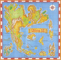
Ultima VII map of Britannia

Included with Ultima VII was this cloth map.
Description[edit]
The map showing Britannia is somewhat different from its predecessors. The map is much more precise than the maps before it, putting many buildings precisely onto the map. It also looks more scientific, with only few decorations being on it. The map also has an excuse for Ambrosia and the Isle of Fire, hiding them beneath the banner and the compass rose. It is supposed to be the same map with which the Avatar arrives in Trinsic. Due to the in-game map, it has only limited use in gameplay. It is, however, needed for the copy protection, since there will be questions about the longitudes and latitudes on the game map.
Other Releases of the Map[edit]
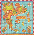
The European version of the map differs from the North American one. The European map has a thick, yellow border around the map, while the American version has a thin brown border. The material is thinner and the print rather mediocre in many of the European versions, making it necessary to put a longitude and latitude chart into the box for the copy protection, since the numbers were unreadable. On the other hand, the runic on the map is easier to read on a European map. The European cloth map can been seen below.
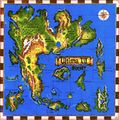
The later CD-Editions of The Complete Ultima VII, apart from some early European releases, do not have cloth maps and instead use a paper map (such as the one pictured here). The Ultima VII logo on the map is a bit different than on the original cloth map. Also, the paper map is a bit less colorful than the cloth map. The Polish, Spanish and Korean versions of the game also only ever shipped with the same paper map. The SNES-port of Ultima VII also included a paper map, which is a photograph of the cloth map with all the runic and the game title removed and new labels put in – though it was useless for that port due to the changed geography. The paper maps can be seen below.
Interestingly, the Taiwanese cloth map got heavily revamped. While the line art is the same, the colors, which in the original heavily leaned upon yellows and oranges, here tend much more to greens. The entire map feels different and is also included in the gallery below.
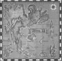
Additionally, the CD-only versions of The Complete Ultima VII had the map as a PDF. Surprisingly, the map is not in color, but instead in grainy black-and-white. This could be chalked up to the generally bad quality of the PDF format back in 1995, yet it does stick out. The map itself is a copy of the paper map, as can be seen at the visible folds.
Alternate Maps[edit]
The paper map
The European cloth map
The PDF-map from the CD-only version
Cloth map of the Taiwan version
The map included with the SNES-port of Ultima VII


Trivia[edit]
- The label for the Fens of the Dead was placed so awkwardly, that they may be confused the islands north of Paws, most notably done by the page Mysterious Sosaria in their atlas.
- Some changes in the shape of the world – like further shrinking Spiritwood – came so late, that the map does not reflect them.
Gallery[edit]
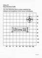
The coordinate chart from the European edition
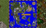
The map as envisioned in-game


See Also[edit]
- HRUMP: High-Res Ultima Map Project – who graciously gave us permission to host their maps
- SNES map for Ultima VII
- Ultima Atlas
- Ultima VII computer-generated map
| Maps Included as Trinkets | |
|---|---|
| Maps | Ultima I ☥ Ultima II ☥ Ultima III ☥ Ultima IV ☥ Ultima V ☥ Ultima VI Ultima VII ☥ Ultima VII Part Two ☥ Ultima VIII ☥ Ultima IX Savage Empire ☥ Martian Dreams ☥ Ultima Underworld ☥ Ultima Underworld II Ultima Forever ☥ Shroud of the Avatar |