File:Ultima2 InterplanetaryMap.png
Original file (1,298 × 453 pixels, file size: 49 KB, MIME type: image/png)
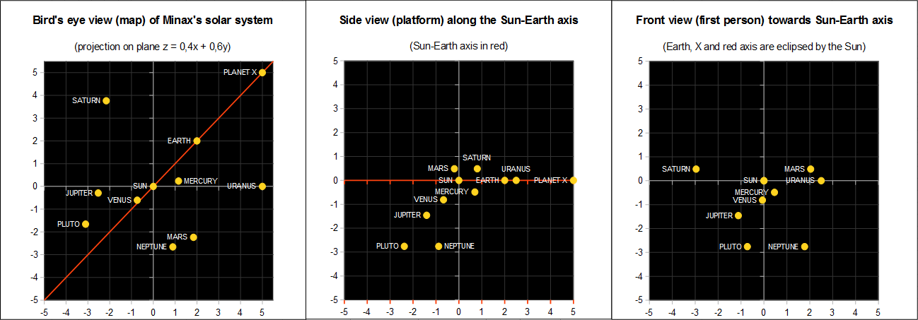
Monge's projections (familiar example) of the Solar System in Minax's 2112.
In order to get a two-dimensional representation (map) of a three-dimensional space, it is necessary to project all points of interest (planets) on a chosen plane.
A plane is determined by three misaligned points. The natural choice would have been: Earth, Sun, Planet X. Unfortunately, such three planets were aligned, therefore a fourth point had to be chosen.
In order to have a map that represents the relative three-dimensional distances with minimal distortion, the best plane is the one where all planets are as close as possible to the inter-planetary plane itself.
Therefore, these were the two criteria to choose the plane:
- it has to include the Sun-Earth axis;
- the sum of the distances from the plane to each of the planets has to be minimal.
Equation of the plane from criterium n.1: " z = ax + (1-a)y ", where "a" is a parameter to be determined using criterium n.2.
After thorough mathematical analysis (contact me for details), it was determined that the requested plane was the one passing through Uranus (plus the aforementioned Sun, Earth and X).
The full two-dimensional representation of the three-dimensional space was completed as Monge's orthogonal projections; using video games language: bird's eye map, platform view, first person view.
File history
Click on a date/time to view the file as it appeared at that time.
| Date/Time | Thumbnail | Dimensions | User | Comment | |
|---|---|---|---|---|---|
| current | 07:31, 19 May 2017 | 1,298 × 453 (49 KB) | Abacos (talk | contribs) | Category:Ultima II images |
You cannot overwrite this file.
File usage
The following 2 pages use this file: