User talk:Browncoat Jayson/Sandbox
Jump to navigation
Jump to search
Ohh... image map looks snazzy. That would be awesome replacing all of the current Britannia map images. Dungy 17:05, 23 December 2011 (PST)
- While I do appriciate the work, I generally follow the principle that the more complicated you make something, the easier it can break, thus why I prefer seperate map files. However, something like that on the Britannia page to select where to go would be nice, maybe with a more detailled image. Mysterious Sosaria has such a map as well.--Tribun 17:26, 23 December 2011 (PST)
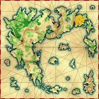
- Man, I really like my own suggestion... (is that bad?) I actually found a custom-made map that with some editingwould be ideal for a clickable map, as everything (apart from the western Valoian Isle) is on it. You can see it on the right.--Tribun 17:53, 23 December 2011 (PST)
- I was planning, once I get the map edited to include things that actually look clickable, to see if we wanted to use that on the main navigation page. If you'd prefer something like that map above, it is certainly do-able. I'd used all of the various place maps to create a single map that shows all of the islands and such, but it wouldn't be too hard to modify that map, I don't think. I'll finish off what I was working on, and if we use a different map, that's fine too. --Browncoat Jayson 12:23, 26 December 2011 (PST)
